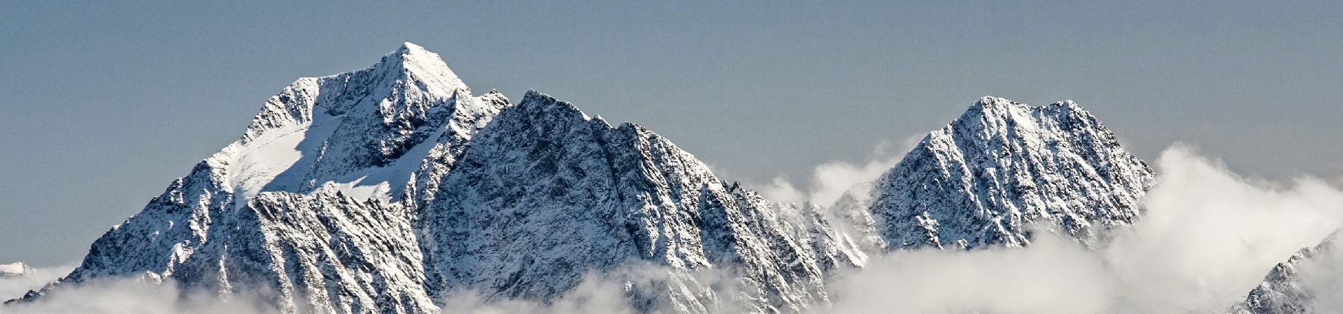
The Lemosho Route is considered the most beautiful route trek on Mount Kilimanjaro. As a newer route, it is more remote and arguably more beautiful, but a bit longer and slightly more expensive. It starts on the Western side of the mountain at the Londorossi Gate, which is a further drive from town, and was introduced as an alternative to the Shira route. After beautiful forests and moorlands it crosses the Shira Plateau on day 3 to connect with the Machame Route at Lava Tower and down towards Barranco Valley via the Southern Circuit. You may be lucky enough to see buffalo, elephant and other game. Because this route can be done over a longer period of time for acclimatization, it has a higher success rate of summit.
Lemoshe route Kilimanjaro trek Miles: 47.5 Round Trip
The Success Rate is around 90% on 8 days itinerary. As a newer route, it is more remote and arguably more beautiful, but a bit longer and slightly more expensive. Because this route can be done over a longer period of time for acclimatisation, it has a higher success rate of summit.
- high success rate.
- better acclimatization.
- spectacular views of west Kilimanjaro.
Itinerary
Day 1 Londorossi Gate (7,742ft/2,346) to Mti Mkubwa (9,498ft/2,878m)
Distance: 7 km/4 miles
Hiking Time: 3-4 hours
Habitat: Rain Forest
Starting in the morning after breakfast, drive to Londorossi gate from the hotel in Moshi. The drive takes about 4 hours. Do all registration at Londorossi gate, and then transfer to the Lemosho starting point where the trek begins through the rain forest until Mti Mkubwa (Big Tree) camp for dinner and overnight.
Day 2 Mti Mkubwa Camp (9,175ft/2,780m) – Shira 2 Camp (12,870ft/3,900m)
Distance: 17km/10.5miles
Environment: Moorland
Time: 5 to 6 hours
Walk along the thin trail through the rainforest, the vegetation becoming scarcer and scarcer until finally reach moorland filled with Lobelia and Eric plants. Ascending through rolling hills, reach Shira 1 Camp for lunch, witness the snow-capped summit of Kibo looking over the Shira plateau. After lunch continue to Shira 2 Camp, the terrain is much flatter than it was before, the hike will seem more leisurely, enjoy fantastic views of the Great Rift Valley and Mount Meru.
Beautiful and distinctive Giant Lobelias still dot the moor landscape. Walking on ground where lava used to flow, reach to the Camp for dinner and overnight.
Day 3 Shira 2 Camp (12,870ft/3,900m) to Lava Tower (15,190 ft/4,785m)
Distance: 7 km/4.3 miles
Hiking Time: 4-5 hours
Habitat: Alpine Desert
Lava Tower (15,190 ft/4,785m) to Barranco Camp (13,044 ft/4,182m)
Distance: 4 km/2.4 miles
Hiking Time: 2-3 hours
Habitat: Alpine Desert
After breakfast, continue to the east up a ridge and then head southeast towards the Lava Tower camp (15,190ft/4,785m), a 300 ft tall volcanic rock formation. After lunch, we descended to Barranco Camp (3953m/13,000ft) through the strange but beautiful Senecio Forest to an altitude of 13,000 ft.
Beginning and end of the day at the same elevation is not a problem. The time spent at higher altitude (Lava Tower) is very beneficial for acclimatization.
Day 4 Barranco Camp (13,044 ft/3,953) to Karanga Camp (13,106 ft/3,972m)
Distance: 6 km/3.7 miles
Hiking Time: 4-5 hours
Habitat: Alpine Desert
The day starts by descending to the base of the Great Barranco Wall. Then, from the base, started to climb the non-technical but steep, nearly 900 ft cliff. From the top of the Barranco Wall, the trail crosses hills and valleys until it descends sharply into Karanga Valley (Karanga River), the last water point. Then started climbing up to Karanga Camp, arriving there for lunch.
Later in the afternoon, followed by a shorter acclimatization walk, then dinner and overnight.
Day 5 Karanga Camp (13,106 ft/3,972m) to Barafu Camp (4,646m/15,331 ft)
Distance: 4 km/2.4 miles
Hiking Time: 3-4 hours
Habitat: Alpine Desert
From Karanga Camp, the route continues up to the rocky section until Barafu Camp. At this point, the Southern Circuit is completed, which offers views of the summit from many different angles. Arrive at the camp, rest, followed by an early dinner, and prepare for the summit. When the weather gets clear, the view of the two peaks of Mawenzi and Kibo can be seen.
Day 6 Barafu Camp (15,331 ft/4,646m) to Uhuru Peak (19,341 ft/5,895m)
Distance: 6 km/3.7 miles
Hiking Time: 6-7 hours
Habitat: Arctic
Uhuru Peak (19,341 ft/5,895m) to Mweka Camp (3,100m/10,065 ft)
Distance: 12 km/7 miles
Hiking Time: 4-6 hours
Habitat: Rainforest
Starting at midnight begins the push to the summit, the most mentally and physically challenging portion of the trek. The journey will be spent in the wind and cold weather. Ascend in the darkness for several hours while taking some short breaks. Arrive at Stella Point (18,900 ft/5,730m) at sunrise. Then it continued for about an hour from Stella Point to Uhuru Peak, Africa’s highest point on Mount Kilimanjaro.
Spend a short time on the summit taking photographs before starting the descent back to Barafu Camp, which takes about 3 hours. Arrive at Barafu Camp, take a short rest (1-2 hours), then continue descending to Mweka Camp for dinner and overnight.
Day 7 Mweka Camp (10,065 ft/3,100m) to Mweka Gate (5,380 ft/1,630m)
- Distance: 10 km/6.2 miles
- Hiking Time: 3-4 hours
- Habitat: Rain Forest
On the final day, after breakfast and celebrations at the camp, then continue the three-hour descent to Mweka Gate, arrive at the gate and sign out to the national park authority and collect the summit certificates.
A vehicle will be waiting at Mweka Gate and will be transferred back to the hotel in Moshi.
